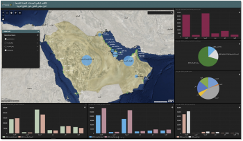
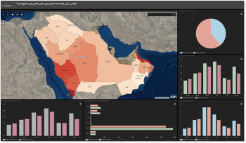
GIS provides services and applications that support the work of the Statistical Center of the Gulf Cooperation Council in the field of statistical data representation on maps, in addition to supporting statistical operations related to the spatial location. The department also produces interactive maps of statistical indicators.
U S E R L O G I N
R E S O U R C E S
S U B S C R I B E
GCC Statistics Offices' Websites


GCC Links
Arab Bureau Of Education For The Gulf States
Gulf Health council
G.C.C Commercial arbitration centre
Council of Ministers of Labour and Ministry of Social Affairs in GCC states
Gulf Organization For Industrial Consulting
Arabian Gulf University
G.C.C Joint Program Production Institution
Gulf Radio and Television Organization
GCC Standardization Organization
Gulf Cooperation Council Interconnection Authority
Accounting and Auditing Organization of the Gulf Cooperation Council (GCC)
Gulf Monetary council
Gulf Economic Interactive Gate
Advisory Board of the Supreme Council
Regional Links
International Links
GCC Member States Online Portals
Copyrights © 2014- (Version 3.0) GCC Statistical Center (GCC-STAT)